


la cotes'aime - la balme

XavierFaidix
User
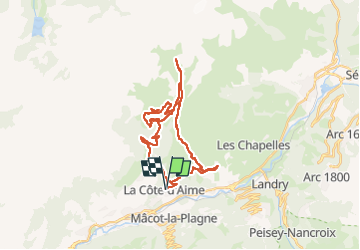

Length
34 km

Max alt
1996 m

Uphill gradient
1516 m
Km-Effort
54 km

Min alt
971 m

Downhill gradient
1520 m
Boucle
Yes
Creation date :
2025-06-06 08:19:41.044
Updated on :
2025-06-06 20:20:25.948
3h38
Difficulty : Difficult

FREE GPS app for hiking
 SityTrail
IGN / Geographical institutes
SityTrail Plus
The world is yours!
About
Trail Mountain bike of 34 km to be discovered at Auvergne-Rhône-Alpes, Savoy, La Plagne-Tarentaise. This trail is proposed by XavierFaidix.
Description
eVTT
Positioning
Country:
France
Region :
Auvergne-Rhône-Alpes
Department/Province :
Savoy
Municipality :
La Plagne-Tarentaise
Location:
Unknown
Start:(Dec)
Start:(UTM)
318078 ; 5048620 (32T) N.
Comments